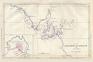
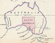
Part Of Southern Australia From The 132° To 141° Degree Of East Longitude, 1836
Click The Image Below For An Enlarged View |
This Image © Copyright MAPCO 2006 |

~ Click For An Enlarged Image ~
The Map
| Full Title: |
Part Of Southern Australia From The 132° To 141° Degree Of East Longitude |
|
| Publisher: |
J. Arrowsmith, London |
| Date: |
28 July 1836 |
| Source: |
First Annual Report of the Colonization Commissioners of South Australia To His Majesty's Principal Secretary of State for the Colonies. 1836. Presented pursuant to Act 4 & 5 Will. IV. c. 95.
Colonial-Office 25 July 1836.
Ordered, by the House of Commons, to be Printed on 28 July 1836 |
| Size: |
32.5cm x 20cm (12¾" x 8") |
| Scale: |
1" : Approx 70 British Statute Miles |
| Extent: |
Mount Arden - Darling River - Cape Northumberland - Fowlers Bay |
| Description: |
Early Colonization Commissioners paper map of South Australia (40 pages). Hand coloured map bound into Report.
|
|
This early map of South Australia was included in an 1836 report to the Parliament in England, entitled "First Annual Report Of The Colonization Commissioners For South Australia To Her Majesty's Principal Secretary Of State For The Colonies. 1836." The enclosed map of South Australia was produced by John Arrowsmith, Mapmaker, and was probably printed by James
and Luke G. Hansard & Sons, Printers.
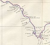
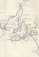
The map records observations made of the landscape and coastline, including "Lagoon seen from Mast Head", "Woody Hills", "Fresh Water", "Lagoon", "Rich Open Forest Land", "Range of level land covered with Wood", "Fine Harbour Discovd. 1833", "Fertile Land", "Undulating Grassy Forest", "Flat & Beautiful
Valley", "Rich Country", "Thickly Wooded", "Flat & Wooded", "Lightly Wooded", "Well Wooded", "Sand Hills", and "Anchorage".
You can click on the map images above for enlarged views the map (enlarged or supersized), or you can view sections of the map here:
|
|
The First Annual Report Of The Colonization Commissioners For South Australia includes the following items:
- Price of Land
- Loans
- Treatment of the Aborigines
- Emigration
- Table of Emigrants (showing the numbers of the Labouring Class and Superior Class)
- The Survey
- Difficulties encountered - Obstacles to be removed
- APPENDIX
- Regulations for the Disposal of Land in the Colony; for the Parliamentary Sales of Colonial Land in this Country; and for the Emigration of Labourers
- Regulations for the Disposal of Lands in the Colony
- Preliminary Sales of Colonial Lands in this Country
- Regulation for the Emigration of Labourers
- Modified Regulations for the DIsposal of Land
- Return of the Sales of Land from the commencement, on the 15th July 1835, to the 31st May 1836; the whole at 12s. per Acre.
- General Information respecting the Colony; Disposal of Land; Regulations for the Selection of Emigrant Labourers; Principals of Colonization
- Map - Part Of Southern Australia From The 132° To 141° Degree Of East Longitude
- Colonization Commission for South Australia
- Proposals for raising a Loan of £80,000
- Conditions
- Letter of Instructions from the Colonization Commissioners for South Australia to Mr. Thomas Gilbert, the Storekeeper
- Report on the Departure of the "Cygnet"
- Report on the Departure of the "Rapid"
- Letter of Instructions by the Colonization Commissioners for South Australia to Colonel William Light, Surveyor-general for the Colony of South Australia
- Letter of Instructions by the Colonization Commissioners for South Australia to G.S. Kingston, Esq., Deputy Surveyor for the Colony of South Australia
- Letter of Instructions by the Colonization Commissioners for South Australia to F.B. Finniss, Esq., one of the Assistant Surveyors for South Australia
- Financial Statement
- The Colonization Commissioners for South Australia, in Account with George Barnes, for Government Revenue Fund
- The Colonization Commissioners for South Australia, in Account with George Barnes, for the Sales of Land and Emigration Fund
- Abstract of Petty Cash Account, from 5 May 1835 to 31 May 1836
- Expenses incurred in Bond Stamps, in Postage, and in Carriage of Parcels
You can also view other early maps of South Australia from the "Second Report Of The Colonization Commissioners Of South Australia", dated 22 December 1837, and the "Third Annual Report Of The Colonization Commissioners Of South Australia" dated Febry 18th, 1839.
I hope that you enjoy these intriguing glimpses into South Australia's early history.
How To Use These Map Pages
Enlarged View:
Click on the map image at the top of this page to view an enlarged image of this map. The enlarged image will display on a new web page.
To navigate back to the main map page (this page), click on the enlarged map image or the map title displayed at the top of the page.
Supersized View:
Click on the small thumbnail map image above to view a very large, highly detailed image of this map. The image file size is quite large, being 1.24Mb, and measuring 3200 pixels wide x 2117 pixels high. This highly detailed image will display on a new web page.
To navigate back to the main map page (this page), click on the enlarged map image or the map title displayed at the top of the page.
|


