MAPCO
MAPCO
R.C.C.R. Services Map of Adelaide & Suburbs c1930-40 MAPCO
MAPCO Store
MAPCO


* PREVIEW PAGE *

Civil Defence Force South Australia. R.C.C.R. Services
Map of Adelaide And Suburbs
c1930-1940


The Map

Full Title:
Civil Defence Force South Australia. R.C.C.R. Services
Publisher:
Unknown
Printer:
Unknown
Map Date:
Pre-1931
Overlay Date:
c1940 (World War II)
Size:
127.5cm x 203cm (50" x 80")
Scale:
1" : 20 Chains
4" : 1 Mile
Extent:
Pelican Point - Stradbrooke - Coromandal Valley North - Mellor Park
Description:

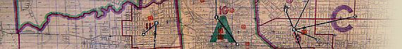
Huge linen backed map of Adelaide and Suburbs, used by the Red Cross Civilian Relief Service, presumably during World War II.

Hand-coloured overlay outlining Adelaide's Civil Defence Force Districts, Casualty Zones, Main Control Centre, Sub-Control Centres, Chief Warden’s HQ, First Aid Posts, Hospitals for Air Raid Casualties and Red Cross Civilian Relief Depots.

An amazing piece of 20th century Adelaide history!


This Image © Copyright MAPCO 2007
Displayed With Permission
R.C.C.R. Services Map of Adelaide & Suburbs c1930-40


Date


This site has been accessed Counter times.


Copyright Date