Map Of Gallipoli - Scale 1:20,000
Kurija Dere / Koja Dere
1915
~ Click Here To View The Map Image Without Borders ~
** View More MAPCO Maps Of Gallipoli **
The Map
| Full Title: |
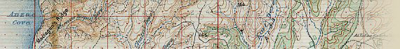
Gallipoli - Scale 1:20,000. Kurija Dere.
Reproduced at the Survey Department, Egypt, 1915. G.S.G.S. 4000. |
|
| Publisher: |
Survey Department, Egypt. |
| Date: |
1915 |
| Size: |
55.8cm x 78.7cm (22½" x 31") |
| Scale: |
2" : 1000 Metres (1 Kilometre) |
| Extent: |
Hetman Chair - Al Tutan Katcha Tekke - Damler - Aegean Sea |
| Description: |
Folding map of Gallipoli, Kurija Dere or Koja Dere region. Folding coloured paper map mounted on linen. Reference to other maps printed on rear of linen.
This copy of the Kurija Dere map is extremely stained, and one must assume that these stains originate from the battlefield around Anzac Cove at Gallipoli. This map has been digitally repaired for clarity of display, but you can view the original stained condition of the map below.
|
Click the link below to view the first assembled scans of the map. On this page you can hover over the image to view the map with and without the stains:

View The Stained Map
Of great interest to Australian and New Zealand researchers will be the section showing Anzac Cove, Maclagan's Ridge, Hell Spit, & Brighton Beach. The contour lines on this section of the map clearly illustrate the formidable landscape that confronted the ANZACs upon landing on the Gallipoli beaches.
Image Sizes and Download Times
The images displayed here are scans of each folded section of the plan. The average image size of the Gallipoli map sections is approximately 130KB. At 56KB dial-up connection speed each page will take about 30 seconds to fully load.
This map also includes 2 clickable enlarged views of each map section. These are accessed by clicking the left and right halves of each map section image. The enlarged images vary in size from 109KB to 451KB, taking between 20 seconds and 60 seconds to load at a 56KB connection speed.
Please be patient, as it is worth the wait.
|


")


