|
Environs Of London 1837
By Thomas Moule

~ Click For An Enlarged Image ~
The Map
| Full Title: |
Environs Of London
|
|
| Map Maker: |
Thomas Moule |
| Engraver: |
Engraved for Moules English Counties by W. Schmollinger |
| Date: |
1837 |
| Source: |
Taken From Moule's "The English Counties Delineated; or, A Topographical Description Of England." |
| Publisher: |
George Virtue & Co. |
| Size: |
26.7cm x 20.9cm (10½" x 8¼") |
| Scale: |
1" : 21/3 Miles (Approx) |
| Extent: |
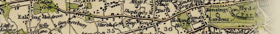
Bounds Green - Barking - Norwood - Hanwell |
| Description: |
Hand coloured engraved paper map of London. Imprint and scale below map. Based on James Bingley's Environs Of London map published 3 Nov 1828 ( Howgego No. 315).
Oval foliate and cornucopia vignette border, with image of Old Father Thames bottom centre. The cornucopia contain (left) fruit, flowers and wheat, representing Agriculture, and (right) ivory, gold chain, pearls, jewels and coins, representing Commerce.
This is a pretty little map of equal artistic and cartographic merit.
|
|
|

Old Father Thames With Cornucopia Representing Agriculture & Commerce.
This beautiful map was taken from Moule's "English Counties Delineated". Moule's English Counties was first published as a complete set in 1837, having previously been issued in parts from 1830 to 1836. The 1837 publication contains 58 maps, the majority being county maps. Moule's maps are highly regarded as the most attractive of all of the county maps of the period, with the Environs of
London being one of the rarest.
The map is embellished with engraved views set outside of the map border, depicting New London Bridge (top left - completed 1831); Suspension Bridge at Hammersmith (top right - completed 1827); Triumphal Arch, Hyde Park Corner (bottom left - completed 1828); and New Post Office (bottom right - completed 1829). Note that over a period of 3 years from 1968 New London Bridge was moved stone by stone to
Lake Havasau, Arizona, U.S.A.
I do hope that you enjoy this beautiful map.
How To Use These Map Pages
Enlarged View:
Click on the map image at the top of this page to view an enlarged image of this map. The enlarged image will display on a new web page.
To navigate back to the main map page (this page), click on the enlarged map image or the map title displayed at the top of the page.
Supersized View:
Click on the small thumbnail map image above to view a very large, highly detailed image of this map. The image file size is quite large, being 3.5Mb, and measuring 3195 pixels wide x 2695 pixels high. This highly detailed image will display on a new web page.
To navigate back to the main map page (this page), click on the enlarged map image or the map title displayed at the top of the page.
|


")

