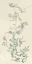
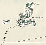
Plan Of The Settlements In New South Wales
By C. Grimes, Deputy Surveyor-General,
1796
Click The Map Image Above For Larger Views
The Map
| Full Title: |
Plan Of The Settlements In New South Wales By C. Grimes Deputy Surveyor-General 1796 |
|
| Date Of Map: |
1796 |
| Mapmaker: |
|
| Publisher: |
Sydney: Charles Potter, Government Printer. |
| Publication Date: |
1895 |
| Source: |
Historical Records Of New South Wales.
Vol. III. - Hunter.
1796-1799.
Edited By F.M. Bladen, Barrister-At-Law. |
| Size: |
37cm x 41.5cm (14½" x 16¼") |
| Scale: |
5" : 10 British Statute Miles (Approx.)
5" : 800 Chains (Approx.) |
| Extent: |
Mulgrave Place - North Head - Bulanaming - Prospect Hill |
| Description: |
Late 19th century reproduction of Charles Grimes's 1796 New South Wales settlement plan of the area around Sydney, as frontispiece to the above publication.
This plan was in very poor condition, with splits to the folds and foxing in parts. To make this a more useable and pleasant research item it has been necessary to digitally repair this map for display.
|
Places recorded on the map include The Terrace, Mulgrave Place, The Road To The Hawkesbury, Prospect Hill, Toongabbee, Duck River, Duck Flats, Field Of Mars, Eastern Boundary, Field Of Concord, Petersham, Bulanaming, Hunters Hill, Sydney Cove, Farm Cove, Garden Cove, Surrey Hills, Garden Island, Blackburn Cove, Keltie Cove, Careening Cove, Rose Bay, Green Point, Point Bradley, Hunter
Bay, Middle Head, Manle Cove, Collins Cove, Camp Cove, Inner South Head, Inner North head, South Head, and North Head.
You can use the thumbnail map above for enlarged views of the main map sections, or you can view enlarged sections of the map here:
The names recorded in the table of References To Grimes's Plan Of The Settlements In New South Wales, 1796 will be transcribed here soon.
I hope that you enjoy these intriguing glimpses into New South Wales very early history.
Image Sizes and Download Times
The average image size of the New South Wales map sections is approximately 190KB. At 56KB dial-up connection speed each page will take about 30 seconds to fully load, although some pages may take slightly longer.
Please be patient, as it is worth the wait.
|


