Port Adelaide
1883
Click Here To View The Map Image Without Borders
The Map
| Full Title: |
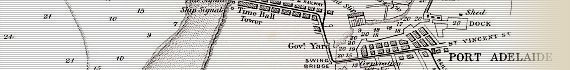
Port Adelaide
H.W.F. & C. IVh. 40m. Spr. rise 8½ feet.
Soundings in ft. at L.W. |
|
| Publisher: |
E.Spiller, Government Printer, North-Terrace, Adelaide. H.B. Lith. |
| Date: |
1883. (Inscription to Title Page of 17 November 1883) |
| Source: |
South Australia: Its History, Productions, And Natural Resources, By. J.P. Stow. Written For The Calcutta Exhibition, By request of the South Australian Government. |
| Size: |
15cm x 21cm (6" x 8¼") |
| Scale: |
Approx 1.4" : 1 Statute Mile |
| Extent: |
Inner Bar - North Arm - Port Adelaide - Outer Bar |
| Description: |
Folding engraved plan on paper, included in Stow's "South Australia", published for the 1883 Calcutta Exhibition.
|
This map of LeFevre Peninsula and Port Adelaide includes a number of interesting features, including the Quarantine Station on Torrens Island, a Powder Magazine, Glanville Fort, Largs Fort, the Fort at the North Arm, a Pine
Grove and Shea Oak Grove, the Time Ball Tower at Semaphore, Gas Lamps at Largs Railway Station, and details of the Swing Bridge and various Wharves in Port Adelaide.
Image Sizes and Download Times
The average image size of the 1883 Port Adelaide map sections is approximately 220KB. At 56KB dial-up connection speed each page will take about 40 seconds to fully load, although some pages can take approximately 60 seconds to load.
Please be patient, as it is worth the wait.
|