MAPCO
MAPCO
A Geological Map Of England, Wales And Part Of Scotland c1836 MAPCO : Map And Plan Collection Online Home Page
MAPCO Store
MAPCO


Back To Map Home Page
Derby, Stafford, Nottingham, & Lincoln
Mull, Argyll, Perth, Dumbarton, & Stirling Forfar, Perth, Stirling, & Fife Note, & Geological & Mineralogical Section From The St. George's Channel To The German Ocean Geological & Mineralogical Section From The St. George's Channel To The German Ocean
Argyll, Arran, Dumbarton, Renfrew, & Ayr Linlithgow, Lanark, Edinburgh, Haddington, Berwick, Peebles, Selkirk, Roxburgh, & Dumfries Northumberland, Explanation Of The Signs, & Explanation Of The Colouring Explanation Of The Colouring
Ireland, Wigton, Ayr, & Kirkcudbright Kirkcudbright, Dumfries, Solway Frith, Cumberland, Westmorland, Northumberland, & Durham Northumberland, Durham, Explanation Of The Colouring, & Note Note, & Explanation Of The Colouring
Ireland, St. George's Channel, & Isle Of Man Lancaster, & York York, & Note Note, Explanation Of The Colouring, & Map Title
Ireland, St. George's Channel, Anglesey, Caernarvon Bay, & Caernarvon Caernarvon, Denbigh, Flint, Liverpool Bay, Lancaster, Chester, Merioneth, & Stafford Derby, Stafford, Nottingham, & Lincoln Lincoln, Norfolk, & Map Title
St. George's Channel, Cardigan, & Pembroke Merioneth, Cardigan, Montgomery, Salop, Radnor, Hereford, & Worcester Leicester, Rutland, Warwick, Worcester, Northampton, Huntingdon, Cambridge, & Bedford Cambridge, Norfolk, Suffolk, & Essex
Pembroke, Caermarthen, Glamorgan, Bristol Channel, & Note On Metalliferous Tracts Of England And Wales Caermarthen, Brecknock, Glamorgan, Monmouth, Gloucester, Bristol Channel, & Somerset Gloucester, Oxford, Buckingham, Bedford, Hertford, Wilts, Berks, Middlesex, London, & Surrey Essex, & Kent
Cornwall, Devon, & Note On Metalliferous Tracts Of England And Wales Somerset, Devon, & Dorset Wilts, Dorset, Hants, Isle Of Wight, Surrey, & Sussex Sussex, Kent, & Strait Of Dover
Cornwall, Devon, & Geological & Mineralogical Section From The Lands End To The German Ocean, Displaying The Mineral Districts Of Cornwall, The Mineral District Of The Tamar, & Dartmoor Devon, English Channel, & Geological & Mineralogical Section From The Lands End To The German Ocean, Displaying Dartmoor, The Mineral Districts Of North & East Devon, Quantock Hills, Bridgewater, The Mineral Districts Of Somersetshire, Mendip Hills, Bristol, Bath, & Cotswold Hills English Channel, & Geological & Mineralogical Section From The Lands End To The German Ocean, Displaying Cotswold Hills, Cricklade, Oxford, Aylesbury, Tring, & St. Albans English Channel, & Geological & Mineralogical Section From The Lands End To The German Ocean, Displaying St. Albans, Hertford, Colchester, & Harwich
** Click The Map Image Below For An Enlarged View **


Click The Image Below For An Enlarged View

This Image © Copyright MAPCO 2011
Click Here For An Enlarged Map Image


Explanation Of The Colouring
Click For Detailed Explanations
Names of Formations
or Groups of Rocks and their average thickness in feet
A
Crag Formation
Crag Formation
about 50 feet.
I
Lower Oolite Formation
about 400 feet.
P
Wenlock & Dudley Rocks
about 1,800 feet.
a
Upper Marine (Bagshot Sand)
Upper Marine
Probably 100 to 200 feet.
J
Lias Formation
Lias Formation
about 500 feet.
P
Horderley & May Hill Rocks
about 2,500 feet.
B
Freshwater Formation
about 150 feet.
K
Red Sandstone Formation
about 900 feet.
P
Builth & Llandeilo Rocks
about 1,200 feet.
C
Lower Tertiary Formation
Probably 400 to 500 feet.
L

Magnesian Limestone Formation

Magnesian Limestone Formation
about 300 feet.
Q
Clay Slate
Clay Slate
Probably 8,000 or 9,000 ft.
D
Chalk Formation
Chalk Formation
from 600 to 1000 feet.
M
Coal Formation
Coal Formation
about 3000 feet.
qr
Mica Slate
Mica Slate
Unknown.
E
Greensand Formation
Greensand Formation
about 300 feet.
m

Millstone Grit & Limestone Shale

Millstone Grit & Limestone Shale
600-700 feet.
R
Granite
Granite
Unknown.
F
Wealden Formation
Wealden Formation
about 900 feet.
N

Carboniferous or Mountain Limestone

Carboniferous or Mountain Limestone
about 2,400 feet.
S
Diallage Rock, Serpentine
Diallage Rock, Serpentine.
Unknown.
G
Upper Oolite Formation
about 1000 feet.
O
Old Red Sandstone
Old Red Sandstone
Varies 100 to 10,000 feet.
T
Greenstone
Greenstone
Unknown.
H

Middle or Coralline Oolite Formation

Middle or Coralline Oolite Formation
about 600 feet.
P
Ludlow Rocks
Ludlow Rocks
near 2,000 feet.
U
Basalt
Basalt
Unknown.
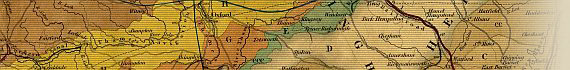
NOTE: Those portions of the various rocks which are known to be metalliferous, are shewn by a darker tint than the general colouring of the map. The strong colours indicate therefore, the position of the various Mining Districts of the Country.


Date


This site has been accessed Counter times.


Copyright Date