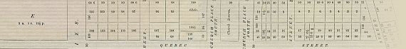
Plan Of Section 2112 B
Port Adelaide
1852
Click The Map Image Above For Larger Views
The Map
| Full Title: |
Plan Of Section 2112 B |
|
| Publisher: |
W.C. Cox, Government Printer, Adelaide |
| Date: |
25th November, 1852 |
| Source: |
An Act to vest portions of Section numbered 2112, in the Provincial Survey of the Public Lands in the Province of South Australia, marked with the letter B, in Trustees to be therein names, so as to enable them to make a good Title to Purchasers thereof, and for any other purposes connected therewith. Assented to 25th November, 1852. |
| Size: |
65.4cm x 54.6cm (25¾" x 21½") |
| Scale: |
25¼" : Approx 1 Mile
15¾" : Approx 1 Kilometre |
| Extent: |
Gawler Reach - Unnamed Creek (Gawler Reach East) -
Tam O'Shanter Creek - Old Port Reach |
| Description: |
Engraved plan on paper, included as Schedule C of an 1852 Parliamentary Paper. Paper strong and complete, with no splitting at folds as often occurs with paper maps of this age. The paper has significant age discolouring and minor foxing, making this a difficult map to scan well.
|
Plan of Port Adelaide, Section 2112 B, from 1852. This plan was annexed to the above mentioned Private Act of 1852 as Schedule C. The Act makes reference to an Indenture for these lands dated 20th July, 1843.
This historic map of Port Adelaide shows the land subdivision and early streets bordered by St. Vincent Street, Port Road (now Commercial Road), Dale Street, and Minories. You can view a large image of the map here.
Use the thumbnail map above for enlarged views of each map section, or you can view the numbered lands and hereditaments, parts and parcels of Section 2112 B here:
View The Section 2112 B Land Parcels
The Private Act of 1852 records the names of the trustees and parties connected with the sale of land in Section 2112 B, Port Adelaide. These include John Hill, John Hart, Jacob Hagen, Edward Hagen, George Marten, John Bentham Neales, Robert Forsyth Macgeorge, Joseph Barrow Montefiore, Robert Stuckey, Thomas Henry Williams, Gregory Seale Walters, Emanuel Solomon, William Paxton, William Henry Clark,
William James, Henry Kent Hughes, Henry Francis Penny, and Charles Fenn and Frederick Wicksteed, Trustees of Mrs. Margaret Neales.
Annexed to the Act are three Schedules recording detailed descriptions of the parcels of land in Section 2112 B. The Schedules are: |
|
Many pioneering families of Port Adelaide would have lived in the houses constructed on these plots of land. A reunion of Port Adelaide's old residents took place at the Town Hall on October 20th, 1937, many of whom would have been descendants of the purchasers of land in Section 2112 B. The gathering was photographed by McNeill Studios, Port Adelaide. The compelling photographic record of this day
is entitled:
Old Folks Reunion.
Town Hall ~ Port Adelaide
Oct 20th 1937
Ralph Wright ~ Mayor.
You can view the photograph by clicking on the image to the right, or on the title above.
|
|
I hope that you enjoy these intriguing glimpses into the early history of Port Adelaide.
Upcoming Port Adelaide Maps
In coming months MAPCO will be displaying a number of other maps and plans associated with Port Adelaide.
"Port Adelaide in 1839" is already online. This map is a small section taken from Colonel William Light's survey of "The District Of Adelaide, South Australia, As Divided Into Country Sections", published February 18th, 1839, by John Arrowsmith, 35 Essex St., Strand, London.
Soon to be displayed will be "Port Adelaide", taken from "South Australia: Its History, Productions, And Natural Resources", by J.P. Stow. Written For The Calcutta Exhibition, By Request Of The South Australian Government. Adelaide. E. Spiller, Government Printer, North-Terrace. 1883.
Image Sizes and Download Times
The average image size of the Port Adelaide map sections is approximately 180KB. At 56KB dial-up connection speed each page will take about 30 seconds to fully load, although some pages can take approximately 50 seconds to load.
Please be patient, as it is worth the wait.
|