A Plan Of The Cities Of London And Westminster,
And Borough Of Southwark, With The New Buildings 1767
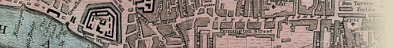
The Map
| Full Title: |
A Plan Of The Cities Of London And Westminster,
And Borough Of Southwark, With The New Buildings 1767 |
| Publisher: |
Anonymous |
| Date: |
1767 |
| Size: |
54cm x 32cm (21" X 12¾")
|
| Scale: |
4¼" : 1 statute mile |
| Extent: |
New River Head - Shadwell - Newington Butts
- Hide Park. |
| Description: |
Folding plan on 18th century paper. Hand
coloured. Title set in top margin. |
This 1767 London plan came from an American collector, who had erroneously attributed
it to John Pine (1690-1756). It is cited in Howgego
(No. 144) as Anonymous, and was most likely published in The Gentleman's
Magazine (first published in 1731 by Edward Cave), The Universal Magazine
of Knowledge and Pleasure (first published 1740), or similar publication.
The plan is split at the folds and has been repaired with archival tape.
How To Use These Map Pages
Use the thumbnail map at the top of each page to navigate your way around the map.
Hovering your mouse pointer over the thumbnails will highlight the individual sections, and display a pop-up message showing the northern and southern extent of that map section, or significant streets, buildings and places. Click the desired area to jump to a page displaying a full size image of that map section. You will need to scroll down the page a little to see the image of the map.
A coloured thumbnail image on the thumbnail map at the top of the page will show you which section of the entire map you are currently viewing.
Click To Enlarge
Once you are viewing the desired map section, you can click on the map image to view an enlarged image of that section. Clicking on the map image allows you to switch back and forth ('toggle') between the normal sized image and the enlarged view of the section.
|