MAPCO
MAPCO
 
Stranger's Guide Through The Streets Of London & Westminster 1814 MAPCO
MAPCO Store
MAPCO


Stranger's Guide Through The Streets Of London & Westminster 1814


Punkers Farm, Road To Watford, Road To Harrow, Bason Of Paddington Canal, Paddington, Edgware Road, Lisson Green, White Lead Manufactury, Lord's Cricket Ground, Liss On Grove, Alsops Buildings, Baker Street North, Park Farm, New Road From Paddington To Islington, Great Queen Street, Gloucester Street, & An Enlarged Plan Of The Rules Of The Fleet Prison Park Farm, Jews Harp, Road To Primrose Hill and Hampstead, Queens Head, Alsops Buildings, Baker Street, Portland Row, New Road From Paddington To Islington, High Street, Upper Harley Street, Portland Place, Wimpole Street, Devonshire Street, Devonshire Place, Weymount Street, Great Marybone Street, New Cavendish Street, Dutchers Street, Mansfield Street, Westmoreland Street, Marybone Street, Charlotte Street, Norton Street, Upper Tichfield Street, George Street, Carburton Street & Queen Street Road To Hampstead, St James's Burying Ground, St. Pancras School, Polygon, Sommers Town, New Road From Paddington To Islington, Tavistock Square, Tottenham Court Road, Reservoir, Nursery, Fitzroy Square, Mortimers Market, Upper Gower Street, Hertford Street, John Street, London Street, Ogle Street, Keppel Street, Bedford Street, Southampton Street, Bedford Street & Russel Square New Road From Paddington To Islington, Small Pox Hospital, Bowling Green House, Pindar Of Wakefield, Highgate And Hampstead Road, Brunswick Square, Foundling Hospital, Queen Square, Great Ormond Street, Grays Inn Garden, Merlins Cave, New River Head, Black Marys Hole, Spa Fields, Blue Lion & House Of Correction City New Road, City Gardens, Dyers Alms House, Quakers School, Orhpans School, St. Johns Road, St. Johns Street, Clerkenwell Green, Red Lions Street, Goswell Street, Charter House, Hemlock Barn, Shepherd & Shepherdess, St. Lukes Workhouse, Brick Lane, Golden Lane, Ironmongers Row, Old Street, Pearless Pool, St. Lukes Hospital, White Cross, Ratcliff Row, Browns Street, Tindals Burial Ground & Bunhill Row City Work House, Westbys Alms House, Turners Square, Coffee House Walk, Alms House, Pleasant Row, Britainnia Gardens, Pimlico, Hoxton, Red Lion Passage, Red Lion Court, Kingsland Road, Ironmongers Alms House, Haberdashers Hospital, Hoxton Square, St. Agnes le Clare, Lyingin Hospital, Royal Row, Artillery Ground, The Curtain, Shoreditch, Cock Lane, Fullers Alms House & Middlesex Place Goldsmiths Alms House, Hags Head, Hackney Road, Bethnal Green New Road, St. Matthews Church, Cambridge Heath & Map Title Cambridge Heath, Bishop Bonners Hall & Map Title
Edgware Road, St. Georges New Burial Ground, Turnpike, George Street, Upper Berkley Street, Upper Seymore Street, Cumberland Street, Quebec Street, Oxford Street, Hyde Park, The Ring, Serpentine River, Grosvenor Gate & Park Lane Baker Street, Portman Square, Manchester Square, Oxford Street, Grosvenor Square, Park Lane, Park Street, Mount Street, David Street, Berkley Square, Chesterfield House, Piccadilly, Foley House, Cavendish Square, New Bond Street, Hanover Square, Great Swallow Street, Old Bond Street & Burlington House Oxford Street, Bedford Square, British Museum, Great Russel Street, Bloomsbury Square, Soho Square, Broad Street, Bloomsbury, 7 Dials, Castle Street, Long Acre, Covent Garden, Golden Square, Piccadilly, Jermyn Street, St. James's Square, Pall Mall, Hay Market, Marlboro House, Charlton House, The Admiralty, Charing Cross, Leicester Square, St. Martins Lane, Kings Mews, Strand & The River Thames Bloomsbury Square, Red Lion Square, Grays Inn Garden, Holborn, Holborn Hill, Furnivals Inn, Drury Lane, Holborn Row, Arch Row, Portugal Row, Lincolns Inn Fields, Lincolns Inn Garden, Chancery Lane, Fetter Lane, Shoe Lane, Strand, Somerset Place, Wych Street, Temple, Temple Garden, Fleet Street & The River Thames Charter House Square, West Smith Field, St. Bartholomews Hospital, Aldersgate Street, Barbican, Red Cross Street, Grub Street, London Wall, Cock Lane, Newgate Street, Fleet Market, Rules Of The Fleet, Old Bailey, Bridge Street, Ludgate, Paternoster Row, St. Pauls Cathedral, St. Pauls Church Yard, Cheapside, Poultry, Watling Street, Blackfriars Bridge, Puddle Dock, Upper Thames Street, Old Fish Street, Cannon Street, Albion Place, Bank Side & The River Thames Finsbury Square, Finsbury Place, Moor Fields, Long Alley, London Wall, Throgmorton Street, Threadneedle Street, Cornhill, Lombardy Street, Little Eastcheap, Gracechurch Street, Fenchurch Street, Lower Thames Street, London Bridge, Bishopsgate Street, Petticoat Lane, Houndsditch, Leadenhall Street, Aldgate, White Chapel, Tower Street, Minoriws, Great Tower Hill, Little Tower Hill & The Tower Map Title, White Chapel, White Chapel Road, Whites Row, Ducking Pond Row, Mile End, London Hospital, The Commercial Road, Goodmans Fields, Well Close Square, Princes Square, Ratcliffe Highway, New Road, Bluegate Fields & St. Georges Church Map Title, Assembly Row, Mile End, Mile End Green, Stepney Green, Footway To Stepney & Limehouse, Mercers Alms House, The Commercial Road, Sun Tavern Fields, Upper Shadwell, Ratcliff Square & The River Thames
Hyde Park, Barracks, Brompton Row, Queens Row, Glocester Row, Kinghtsbridge, Hans Place, Sloane Street, Sloane Square, Whitelands, Chelsea Common, Marlboro Gardens, Blacklands, Coach & Horses, Chelsea & Five Fields Turnpike, Hyde Park, Hyde Park Corner, Piccadilly, St. Georges House, Green Park, Constitution Hill, Upper Grosvenor Place, Queen's Garden, Queen's Palace, St. James's Park, Lock Hospital & Chapel, Dukes Hospital, Pimlico, The Five Fields, Belgrade Place, Upper Belgrade Place, Chelsea Road, Willow Walk, Chelsea Water Works & Bridewell Green Coat School St. James's Palace, St. James's Park, Whitehall, Privy Gardens, Tothill Field, Westminster, Westminster Bridge, Houses Of Parliament, Westminster Abbey, House Of Commons, House Of Lords, New Palace Yard, College Garden, Lambeth & The River Thames Westminster Bridge, The River Thames, Lambeth, Lambeth Palace, Apollo Garden, New Road, Great Surrey Street, New Surrey Street, Lambeth Road, Dog & Duck, Obelisk, West Square & Rules Of The Bench Maid Lane, Bandy Leg Walk, Gravel Lane, Charlotte Street, Duke Street, Queen Street, Melancholy Way, Great Suffolk Street, Dirty Lane, London Road, Newington Causeway, Blackman Street, The River Thames, Borough High Street, Kent Road, Kent Street, Rules Of The Bench, New Halfpenny Hatch, Sessions House & Union Crescent London Bridge, The River Thames, The Tower, St. Catherines, Tooley Street, St. Olaves Street, Pickle Herring Street, St. Thomas Street, Barnaby Or Bermondsey Street, Five Foot Lane, Dog & Bear, Free School Street, Horsley Down Fair Street, Shad, New Road, Long Walk, The Grange Walk, The Kings Walk, The Grange & Queens Head Smithfield, London Docks, Pennington Street, Old Gravel Lane, Tobacco Warehouse, Wapping Street, The River Thames, Rotherhithe Or Redriff, Rotherhithe Or Redriff Street, Cherry Garden Street, Jamaica Street, Millpond Street & Elaphant Street Wapping Wall, Lower Shadwell, The River Thames, Rotherhithe Or Redriff, Redriff Street & Shipwright Street
Chelsea, Paradise Row, Royal Hospital, Franklins Row, Hospital Stairs, Ranelagh, Turks Row, Jews Row, Burying Ground, Grosvenor Row, Wilderness Row, Chelsea Reach, River Thames, Battersea Common Field, Queen Street, & Street List A-B Queen Street, Jennys Whim, Chelsea Reach, River Thames, Battersea Common Field, Neat House Gardens, Mill Bank, & Street List B-E Neat House Gardens, Chelsea Reach, River Thames, Nine Elms, Mill Bank, Portsmount Road, Royal Oak, Vauxhall, Lambeth Butts, & Street List E-H Lambeth Butts, Vauxhall Walk, 3 Coney Walk, Grays Walk, Lambeth Work House, Vauxhall Gardens, Kennington Lane, Princes Place, Chester Place, Newington Butts, Kennington, York Row, Canterbury Row, Pleasant Row, Mansion Row, White Hart Row, Cleaver Street, Princes Street, Queens Row, Assembly Row, & Street List H-M Newington Butts, Church Row, Frances Street, Penton Place, Manor House, Deans Row, Gloster Place, East Lane, Paragon, Walworth, Albion Lane, & Street List M-O Park Place, Cornbury Place, East Lane, Pages Walk, Surry Place, Surry Square, New Road, Kent Road, Bermondsey Spa, Compass Rose, & Street List P-S Blue Anchor Road, Blue House, Blue Anchor, Foot Path, Compass Rose, Map Scale, & Street List S-Y Seven Chimneys, St. Helena Tea Gardens, Halfway House, Midway Place, Road To New Cross, Map Scale, & Street List Note


~ Click Here To View The Map Image Without Borders ~
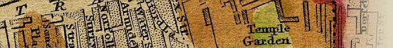


The Map

Full Title:
The Strangers Guide Through the Streets of London and Westminster. &c.
View The Slipcase
Second Title:
A New and Correct Plan of London and Westminster with the latest Improvements.
Slipcase Title:
Wards Plan of London. Printed & Sold by W & T. Darton, Holborn Hill.
Publisher:
Pubd. Jany 12th 1814 by Willm. Darton, 58 Holborn Hill, London.
Date:
1814
Size:
35.5cm x 56cm (14" x 22")
Scale:
3¾" : 1 Statute Mile
Extent:
Somers Town - Ratcliffe - Walworth - Knightsbridge
Description:
First title in top border. Second title in oval at top right. Compass star and map scale at bottom right. Plan of the Rules of the Fleet Prison inset at top left. Map divided into squares lettered for reference and table of references below map. City area, open spaces, etc., are coloured.

Includes a "List of 200 principal streets with letters of reference to their situation" in the bottom margin.

Recorded in Howgego as No. 245 (4).

This beautiful, high resolution map of Regency London is a great resource for students of London history. Genealogists and family historians will find this map of London a useful research aid.

This map of London includes a search engine, designed to search for results within the Darton map pages only. Use the "Search This Map" function at the top of each page to search for streets and place names in William Darton's 1814 map of London.

I hope that you find this feature useful.


Image Sizes and Download Times


The images of Darton's Strangers Guide Through Tthe Streets Of London And Westminster displayed here are scans of each dissected section of the plan, sliced vertically into 2 sections for high resolution display.

The average image size of the darton plan sections is approximately 226KB, although 2 images are displayed on each first view page, making an average size of 453KB.

Each section page includes 2 clickable enlargements (left half and right half of the image). Click on these for a high resolution enlargement of the map section being viewed. The enlarged image sections have an average size of 609KB, the smallest being 495KB and the largest being 747KB. At 56KB dial-up connection speed each enlargement page will take about 60 seconds to fully load, although some pages (such as Bedford Square to Charing Cross) can take approximately 90 seconds to load.

Please be patient, as it is worth the wait.


Date


This site has been accessed Counter times.


Copyright Date