A Topographical Map Of The Country
Twenty Miles Round London
1800
Click Here To View The Map Image Without Borders
The Map
| Full Title: |
A Topographical Map Of The Country Twenty Miles Round London, Planned From A Scale Of Two Miles To An Inch By Willm Faden, Geographer To The King |
|
| Publisher: |
William Faden, Charing Cross |
| Date: |
September 1st, 1800 |
| Size: |
Circular 56cm diameter (22" diameter) |
| Scale: |
½" : 1 statute mile |
| Extent: |
Chelsing - Tilbury - Dorking - Eton. |
| Description: |
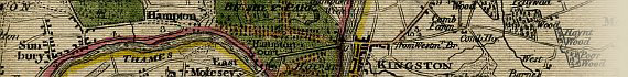
Folding map, hand coloured in outline, with parks coloured. Explanation bottom left and bottom right outside map. Imprint and scale below.
(Howgego Pg 142)
This map is recorded in Howgego as No. 193 (2). The first edition of this map was published by Faden in 1790. The date imprint of this edition has been changed to "Sepr 1st 1800". Paddington Canal is shown on the map.
|
Use the thumbnail images above to navigate this map. Each map section page includes four enlarged views of that section, allowing the map to be studied in the finest detail.
This map of the Country Round London has been framed and on display for the past 9 years. As a result, the age toning of this map is quite pronounced due to UV exposure. This folding map was definitely a traveling map, and as such is a well used and grubby item. It is quite stained in places, but overall is in good condition considering the amount of use it has seen over the centuries. There are a number
of hand written notes in the blank border area.
Unfortunately the slipcase for this map is currently missing. However, Faden's label is affixed to the linen backing of the map. You can click on the image to the right for an enlarged view of the label. |
|
This is the first of many London Environs maps that will be displayed on the MAPCO website.
Image Sizes and Download Times
The images of Faden's Map Of The Country Round London displayed here are scans of each section of the map, divided into quarters for speed of loading. The four separate images that make up each map section have an average combined size of approximately 300KB. At 56KB dial-up connection speed each page will take about 40 seconds to fully load, although some pages can take approximately 80 seconds to
load.
This map includes 4 clickable enlarged views of each map section. These are accessed by clicking the quarters of each map section image (top left, top right, bottom left, and bottom right quarters). The enlarged images vary in size from 255KB to 383KB, taking between 40 seconds and 80 seconds to load at a 56KB connection speed.
Please be patient, as it is worth the wait.
|