| Description: |
Hand coloured engraved paper map of the World, sold by Joseph Cross for the price of 3d.
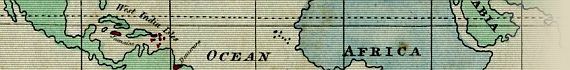
The map shows the extent 30° north and south of the Equator in which sugar is grown. Australia is still shown as New Holland. An unusual little map that would have been the talking point of late-Georgian London.
The primary argument of the author made here against the slave trade is based on the economic burden to the British population in paying duties to support the production of "Slave grown Sugar". This argument was commonly used at the time, in conjunction with contempt for the degrading treatment of slaves kept as property by white masters, to argue the case for the abolition of slavery.
Many magazine and newspaper articles were published on the subject during this period. It must be assumed that the map displayed here was first produced and published in support of one such article. It was included with an article entitled 'Impolicy Of Slavery' published in 'The Kaleidoscope; Or, Literary and Scientific Mirror', on Tuesday 29 June 1824 (No. 209. Vol. IV), which outlined the economic and human cost of the slavery system. The 3 page article with map follows an excerpt from the 'Liverpool Mercury' from 31 October 1823. The article is on unnumbered pages, but follows Pg 414.
The same article was also published as 'Impolicy Of Slavery - East Indian Monopoly, and West Indies Privileges' in The Oriental Herald, in February 1828 (No. 50, Vol. 16, Pg. 341), but without the map being present.
The process of freedom for slaves in the British Empire eventually began under the Slavery Abolition Act of 1833.
|