MAPCO
MAPCO
The Intended New Road From Paddington To Islington January 1756 MAPCO
MAPCO Store
MAPCO


A Plan Of The Intended New Road
From Paddington To Islington
January 1756


Explanation & Tyburn Road Mary le Bone & Berkley Square Tottenham Court & Lincolns Inn Plan Title & Dobney's Bowling Green


The Map

Full Title:
A Plan Of The Intended New Road From Paddington To Islington
Publisher:
B.Cole Sculp
Date:
January 1756
Size:
49cm x 20cm (19¼" x 8")
Source:
Engraved For The Gentlemans Magazine
Scale:
1" : 900 Feet (Approx.)
Extent:
Jews Harp House - Dobney's Bowling Green - Lincolns Inn - Bell Lane
Description:
Folding plan on 19th century paper. Explanation at bottom left. Title at top right. Very good condition.

This plan shows the layout of the proposed new road from Paddington to Islington.

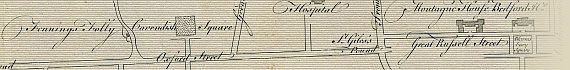
Places of interest include Bell Lane, Lisson Green, Tyburn Road, Jews Harp House, Clay Lane, Mary le Bone, Farthing Pye House, Middlesex Hospital, Cavendish Square, Hanover Square, Grosvenor Square, Berkley Square, Oxford Street, Great Portland Street, St. Giles Pound, St. Giles's Church, Tottenham Court, Footway to Kentish Town, Montague House, Bedford House, Great Russell Street, Bloomsbury Square, Holbourn, Lincolns Inn, Brill Tile Kilns, Battle Bridge, Foundling Hospital, Red Lion Square, White Conduit House, New Burying Ground, Dobney's Bowling Green, and much more.

Click For An Enlarged View Of Dobney's Bowling Green

Enlarged View Of Dobney's Bowling Green

Image Sizes and Download Times

The average image size of the New Road plan is approximately 280KB. At 56KB dial-up connection speed each page will take about 40 seconds to fully load.

Please be patient, as it is worth the wait.


Date


This site has been accessed Counter times.


Copyright Date