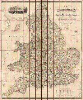
Map
of England
&
Wales
by S.
Lewis
&
Co., London
c1840
Click Here For A Large View Of This Map
(* Dial-Up Users Please Note - This Is A Large Page! *)
The Map
| Full Title: |
Map of England & Wales
Divided into Counties, Parliamentary Divisions and Dioceses.
Shewing the Principal Roads, Railways, Rivers & Canals and the seats of the Nobility and Gentry. With the distance of each town from the General Post Office, London.
Projected from the triangulation for the survey made under the Direction of the honorable The Board of Ordnance |
|
| Map-Maker: |
Drawn by R. Creighton. Engraved by J. Dower. |
| Publisher: |
Published by S. Lewis & Co., London. |
| Date: |
c1840 |
| Size: |
172cm x 208cm |
| Scale: |
1" : 5 miles |
| Extent: |
England & Wales |
| Description: |
Lewis's Map Of England And Wales is on four separate sheets measuring 86cm x 104cm, each bound in green straight grained Morocco leather with gilt embossing to boards and spines. The Morocco leather bindings measure 14cm x 22cm.
|
|
The four folding maps together measure a massive 172cm x 208cm. Each map is dissected into 35 sections and laid on linen, making 140 sections in total. The Lewis map is finely engraved, and has a lovely cartouche of The General Post Office, London, in the top left corner.
This map is a great research aid for genealogists and family historians. |
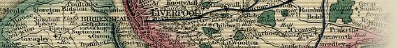
Dating This Map
Research suggests that the N-E division of Lewis's Map of England and Wales displayed here dates closer to 1854 than c1840. This can be determined by the extent of the railway shown on the map. For instance, the railway first reached Bradford, Yorkshire, in 1846, and this line is shown here on the N-E division of Lewis's map. The section of railway between Bradford
to Halifax was opened in 1854, and this is shown as proposed but not completed on the N-E division of the map, suggesting a date in the early 1850s. A precise date is difficult to determine, but 1846-1854 for N-E division of the map is certain. Extensive study of the extent of the railway shown on the map would probably narrow it down to a few years within this period.
While it is likely that the four bound divisions (N-W, N-E, S-W, & S-E) of the map were published at the same time, it is possible that each division was published separately. In this case the railway shown on each division would only assist in dating that particular division, and not the entire map. What is certain is that the original Lewis map was published c1840, and MAPCO also possesses the two
northern divisions with the date 1840 clearly shown in the map title. All later maps would have been updates of the original publication. Sections of these two earlier divisions will eventually be displayed on the site.
(MAPCO's sincere thanks to Norman Gallop for helping to date the North East Division of the Lewis map)
Image Sizes and Download Times
The images of Lewis's Map Of England And Wales displayed here are scans of each
section of the map, divided into quarters for speed of loading. The four separate
images that make up each map section have an average combined size of approximately
375KB. At 56KB dial-up connection speed each page will take about 60 seconds to
fully load, although some pages can take approximately 100 seconds to load.
The navigation image for this map does not include a 'position marker' for the map section being viewed. This approach was necessary to keep the loading time as short as possible for dial-up users. So, unlike the other maps displayed on the site, you will need to pay more attention to exactly where you are when viewing the Lewis map.
This map also includes 4 clickable enlarged views of each map section. These are
accessed by clicking the quarters of each map section image (top left, top right,
bottom left, and bottom right quarters). The enlarged images vary in size from
200KB to 600KB, taking between 40 seconds and 100 seconds to load at a 56KB connection
speed.
Please be patient, as it is worth the wait.
|