|
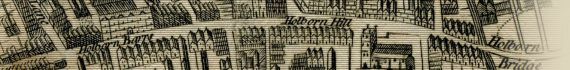
Part of Visscher's Panoramic View of London, 1616.

~ Click For An Enlarged Image ~
The Map
| Full Title: |
Part of Visscher's Panoramic View of London, 1616. |
| Map Maker: |
John Thomas Smith |
| Date: |
1616 |
| Source: |
Taken from "Antiquities Of The City Of Westminster" by John Thomas Smith, 1807; containing "Sixty-Two Additional Plates To Smiths Antiquities Of Westminster" by John Thomas Smith, c1809. |
| Publisher: |
London. Published as the Act directs, June 3d, 1809, by John Thomas Smith, No. 4, Polygon, Somers Town. |
| Plate Size: |
23.7cm x 30.3cm (9½" x 12" Approx) |
| Extent: |
Garden Stairs - Whitefriars Stairs |
| Notes: |
Copied from Claes Jansz Visscher's panorama of London c1616
The caption below the view reads: |
C J Visscher Delineavit
Note - Delineavit from Latin (with abbreviations of delin., delt., del.) meaning "he drew". |
Etched by Richd Sawyer |
These copies are from portions of an extremely rare print by Visscher, the apparent circumstances of which evince it to have been taken early in the reign of King James 1st many years prior to Hollar's time. For the loan of this very rare curious relic the publisher is endebted to the liberality of John Dent, Esq., M.P. & F.A.S.; in whose magnificent
library it is deposited. The lowermost view is the more extensively interesting as it exhibits the manner of a Royal procession by water of which it is apprehended no delineation of an earlier date is now extant. |
London. Published as the Act directs, June 3d, 1809, by John Thomas Smith, No. 4, Polygon, Somers Town. |
How To Use These Map Pages
Enlarged View:
Click on the map image at the top of this page to view an enlarged image of this map. The enlarged image will display on a new web page.
To navigate back to the main map page (this page), click on the enlarged map image or the map title displayed at the top of the page.
|