|
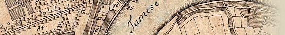
Plan des Villes de Londres et de Westminster et de leurs Faubourgs avec le Bourg de Southwark.
Par de Fer Avec Priv du Roy 1700

~ Click For An Enlarged Image ~
The Map
| Full Title: |
Plan des Villes de Londres et de Westminster et de leurs Faubourgs avec le Bourg de Southwark. Par de Fer Avec Priv du Roy 1700.
|
|
| Map Maker: |
Charles Inselin sculpt. |
| Date: |
1700 |
| Source: |
Unknown |
| Publisher: |
Nicholas De Fer, Paris. 1700. |
| Size: |
22.2cm x 33cm (8¾" x 13") |
| Scale: |
3" : 1 Statute Mile (Approx) |
| Extent: |
Old Street - Ratcliff Cross - Kennington - St. James's Park
52. Vieille Rue - 111. Croix de Ratcliff - 74. Keunington - 34. St. James |
| Description: |
Early plan of London, in French. Key reference table identifying 113 locations throughout London.
Dated 1700 as per Howgego as No. 44 (1), but without the description of London at top right, as per Howgego as No. 44 (2).
|
How To Use These Map Pages
Enlarged View:
Click on the map image at the top of this page to view an enlarged image of this map. The enlarged image will display on a new web page.
To navigate back to the main map page (this page), click on the enlarged map image or the map title displayed at the top of the page.
Supersized View:
Click on the small thumbnail map image above to view a very large, highly detailed image of this map. The image file size is quite large, being 3.4Mb, and measuring 4109 pixels wide x 2784 pixels high. This highly detailed image will display on a new web page.
To navigate back to the main map page (this page), click on the enlarged map image or the map title displayed at the top of the page.
|

")

