|
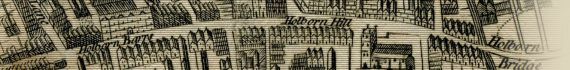
Breadstreet Ward And Cordwainers Ward With Their Divisions Into Parishes According To A New Survey, 1772.

~ Click For An Enlarged Image ~
The Map
| Full Title: |
Breadstreet Ward And Cordwainers Ward With Their Divisions Into Parishes According To A New Survey. |
|
| Map Maker: |
John Noorthouck |
| Date: |
1772 |
| Source: |
Taken from "A New History of London, Including Westminster and Southwark, to which is added, A General Survey of the Whole; Describing The Public Buildings, Late Improvements, &c. Illustrated With Copper-Plates." by John Noorthouck. London, 1773. |
| Publisher: |
Printed For Noorthouck's History Of London 1772.
Printed for R. Baldwin, 47, Pater-Noster Row. 1773. |
| Plate Size: |
25cm x 19cm (9¾" x 7½" Approx) |
| |
|
How To Use These Map Pages
Enlarged View:
Click on the map image at the top of this page to view an enlarged image of this map. The enlarged image will display on a new web page.
To navigate back to the main map page (this page), click on the enlarged map image or the map title displayed at the top of the page.
Supersized View:
Click on the small thumbnail map image above to view a very large, highly detailed image of this map. The image file size is quite large, being 6.7Mb, and measuring 6200 pixels wide x 4158 pixels high. This highly detailed image will display on a new web page.
To navigate back to the main map page (this page), click on the enlarged map image or the map title displayed at the top of the page.
|


")

