MAPCO
MAPCO
Kelly's Post Office Directory Map Of London 1886 MAPCO
MAPCO Store
MAPCO


Kelly's Post Office Directory Map Of London 1886.
Metropolitan Goods Conference. Map Of Collection & Delivery Boundaries.


Brent Reservoir, Dollis Hill, Neasden, Sherrick Green, Willesden, & Willesden Green Golders Green, North End, Hampstead Heath, Childs Hill, Hampstead, Cricklewood, Shoot Up Hill, West End, Roslyn Park Estate, & St Johns Wood Bishops Wood, Caen Wood, Highgate, Dartmouth Park, Gospel Oak, South End, Belsize, Belsize Park Estate, Kentish Town, Primrose Park, Primrose Hill, & Camden Town Finsbury Park, Upper Holloway, Lower Holloway, Highbury, Cattle Market, & Islington New River Reservoirs, Stamford Hill, Stoke Newington, Highbury New Park, Shacklewell, Hackney Downs, Dalston, Islington, Hackney, & London Fields Leyton Marsh, Upper Clapton, Lower Clapton, Homerton, Hackney, Hackney Marsh, Hackney Common, & Victoria Park Leyton, Hackney Marsh, Stratford, & West Ham Park Stratford, & West Ham
Harlesden Green, Old Oak Common, Kensal Green, Wormwood Scrubs, East Acton, & Shepherds Bush Kensal New Town, Westbourne, Kensington Park, Holland Park, Kensington, & Kensington Gardens St Johns Wood, Primrose Hill, Regents Park, Camden Town, Lords Cricket Ground, Paddington, Hyde Park Green Park, & Buckingham Palace Camden Town, London W.C., Westminster, The River Thames, Southwark, & Lambeth Hoxton, Finsbury, London, The River Thames, & Southwark Victoria Park, Oldford, Bow, Mile End, Tower Hamlets, Bromley, Bow Common, Stepney, Limehouse, The River Thames, & Rotherhithe West Ham, West Ham Abbey, Plaistow, Bromley, West Ham Abbey Marsh, Canning Town, Plaistow Marsh, Poplar, Blackwall, Royal Victoria Docks, The River Thames, & Bugsbys Marshes Plaistow, Plaistow Marsh, & Royal Victoria Docks
Ravens Court Park, Hammersmith, Fulham, The River Thames, Chiswick, Castelnau, Barnes, Barnes Elms Park, Barnes Common, & Putney Earls Court, South Kensington, New Brompton, Walham Green, Eel Brock Common, Fulham, The River Thames, & Putney Brompton, Chelsea, The River Thames, Battersea Park, Battersea Rise, & Clapham Westminster, The River Thames, Lambeth, Newington, Kennington, South Lambeth, Clapham, Stockwell, North Brixton, & Angel Town Estate Bermondsey, Walworth, Hatcham New Town, Camberwell, Peckham, Denmark Hill, Champion Hill, & Peckham Rye Rotherhithe, Southwark Park, The River Thames, Millwall Docks, Deptford, New Cross, Hatcham, & Nunhead Millwall Docks, Isle Of Dogs, Greenwich Marshes, East Greenwich, Charlton, Greenwich, Greenwich Park, Blackheath, & Blackheath Park Charlton, & Blackheath
Putney Park, Roehampton, & Putney Heath Wandsworth, Middle Park, & St Anns Hill Wandsworth Common, Clapham Common, Clapham Park, & Balham Hill West Brixton, East Brixton, Herne Hill, Brixton, Brixton Hill, & Tulse Hill East Dulwich, Peckham Rye Common, & Dulwich Rye Hill, Oak Of Honor Hill, Lewisham, Ladywell, Brockley, Brockley Hill, & Rushey Green Lewisham, Lee, Lewisham Park, Hither Green, Kidbrook, & Lee Green Kidbrook, & Lee Green


The Map

Title:
Map Of London Published In The Post Office London Directory For 1886.
View The Cover
Overlaid Title:
Metropolitan Goods Conference. Map Of Collection & Delivery Boundaries. January 1st 1886.
Publisher:
Lithog. Kelly & Co. London & Kingston.
Printed & Published By Kelly & Co. Post Office Directory Office, 51 Great Queen Street, Lincoln's Inn Fields, London. W.C.
Date:
January 1st 1886
Size:
66cm x 90cm (26" x 35½")
Scale:
3": 1 Statute Mile
Extent:
Highgate - Plaistow - Dulwich - Chiswick
Description:
Paper title stuck over previous map title top right. Scale bar top right.

Paper labels stuck on in right hand margin:

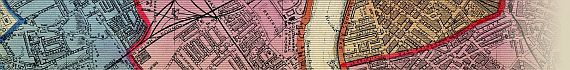
"The Pink Boundary Includes St. George's Road, Green Street To Upton Park Station (L.T. & S.R.)"
"Includes Albert Docks And Firms Between The Docks And The River Side."

Recorded in Hyde as No. 61 (29), but with 1886 dated title similar to Hyde No. 61 (12) dated April 1st 1869.


How To Use These Map Pages

Use the thumbnail map at the top of each page to navigate your way around the map.

Hovering your mouse pointer over the thumbnails will highlight the individual sections, and display a pop-up message showing the areas covered by that section of the map. Click the desired area to jump to a page displaying a full size image of the map section. You will need to scroll down the page a little to see the image of the map.

A coloured thumbnail image on the thumbnail map at the top of the page will show you which section of the entire map you are currently viewing.


Click To Enlarge

Once you are viewing the desired map section, you can click on the map image to view an enlarged image of that section.

Clicking on the map images allows you to switch back and forth ('toggle') between the normal sized image and the enlarged view of the section.


Date


This site has been accessed Counter times.


Copyright Date