Stanford's Map Of London
Showing The Boundaries Of Parishes,
Ecclesiastical Districts, And Poor Law Divisions
1877
The Map
| Full Title: |
Map Of London Showing The Boundaries Of Parishes, Ecclesiastical Districts, And Poor Law Divisions. |
| Publisher: |
Published by Edward Stanford, 55, Charing Cross, London. |
| Date: |
Original map published July 2nd, 1875. This copy revised July 1877. |
| Size: |
79cm x 58.5cm (31" x 23") |
| Scale: |
3" : 1 statute miles |
| Extent: |
Holloway - River Lea - Clapham Common - Hammersmith |
| Description: |
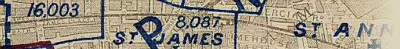
Folding map. Sections laid down on linen. Hand coloured in outline. Explanation, scale bar, and imprint in bottom margin. The population of each district is shown.
Recorded in Hyde as No. 157 (1).
|
This map is a very useful tool for researching the location and extent of London parishes in the latter half of the 19th century.
A note in bottom left margin of Stanford's parish map of London reads: "Published For The Metropolitan And National Nursing Association, 23 Bloomsbury Square, & Corrected To July 1877."
A key is shown in the bottom left margin:

An explanation in the bottom left margin reads: "The numbers refer to the population of each district as given in the London & Rochester Dioceses Book for 1877."
An explanation in the bottom right margin reads: "Under an Act of Parliament of 1875 the Ecclesiastical districts North of the Thames in this Map are in the Diocese of London (except St. Paul's Christchurch, and St. John's Stratford & West Ham which are in St. Alban's) and those to the South of the Thames are in Rochester."
How To Use These Map Pages
Use the thumbnail map at the top of each page to navigate your way around the map.
Hovering your mouse pointer over the thumbnails will highlight the individual sections, and display a pop-up message showing the northern and southern extent of that map section. Click the desired area to jump to a page displaying a full size image of that map section. You will need to scroll down the page a little to see the image of the map.
A coloured thumbnail image on the thumbnail map at the top of the page will show you which section of the entire map you are currently viewing.
Click To Enlarge
Once you are viewing the desired map section, you can click on the map image displayed to view an enlarged image of that section. Clicking on the displayed map image on any page allows you to switch back and forth (toggle) between the normal sized image and the enlarged view of the map section.
|