|
Pigot & Co.'s
Metropolitan Guide & Book Of Reference
To
Every
Street,
Court,
Lane,
Passage,
Alley
And Public
Building,
In The
Cities
Of London
&
Westminster,
The Borough
Of Southwark,
&
Their
Respective
Suburbs
&
Miniature Plan Of London & Vicinity
With
The Geographical
Bearings
From The
Dome Of
St. Paul's
c1820
The Map
| Book Title: |
Pigot & Co.'s Metropolitan Guide & Book Of Reference
To Every Street, Court, Lane, Passage, Alley And Public Building, In The Cities
Of London & Westminster, The Borough Of Southwark, And Their Respective Suburbs.
Compiled & Arranged from Actual Survey & accompanied with a New Plan of London
divided into Seventy districts, which are referred to by figures in the Street
& List. - The whole made so easy of Comprehension as to be essentially valuable
to Strangers, & of the greatest use to the resident Nobility, Gentry, Merchants,
Tradesmen, &c. |
|
| Map Title: |
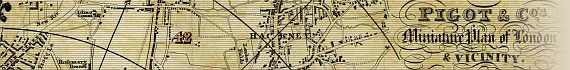
Pigot & Co.'s Miniature Plan Of London & Vicinity, With The Geographical
Bearings From The Dome Of St. Pauls.
Formed into 70 Divisions by means of Circular &c. lines each Circle being
6 Furlongs or ¾ of a Mile from the next when measured in a direct line. |
| Publisher: |
J. Pigot & Co. 24 Basing Lane, London, & 16
Fountain St., Manchester |
| Date: |
c1820 |
| Size: |
27cm x 41.3cm (10¾" x 16¼") |
| Scale: |
c17/8" : 1 statute mile |
| Extent: |
Islington - East India Docks - Camberwell - Kensington
Gardens |
| Description: |
Folding map, included with Pigot & Co.'s Metropolitan
Guide. Title at top right. Scale near bottom centre. 70 divisions of map numbered
for reference to the street index. Waterloo and Southwark Bridges and Stamford
Street shown, but not York Road, Lambeth. Carlton House shown. |
Pigot & Co.'s Miniature Plan Of London & Vicinity is recorded in Howgego
as being c1820 (No. 284), although Howgego
records Pigot & Co.'s Metropolitan Guide & Book Of Reference as c1823
(No. 298) with a different fold-out map included in the book.
The copy of Pigot & Co.'s Miniature Plan Of London & Vicinity displayed
here is is sadly in very poor condition, being split and separated along all folds.
The London Metropolitan Guide street index is comprehensive, but requires the
other more detailed maps displayed on this site to
precisely locate individual streets. The 70 divisions on the map are formed by
¾ of a mile circular lines radiating from the dome of St. Paul's. These
divisions merely indicate the sector of London in which the streets are located.
The Explanation given on the map best explains their
use:
"To find any place wanted expiditiously look in the Street
List, & (for Example) preceeding Fleet St. Temple bar, will be
found a figure of Seven, which corresponds
with the Number of division on the Map in
which Fleet St. will be found: the same rule must be observed with any other place
of public building wanted in the Metropolis."
Image Sizes and Download Times
The images displayed here are digitally reassembled from the split map sections.
The average image size of the Pigot map sections is approximately 300KB. At 56KB
dial-up connection speed each page will take about 50 seconds to fully load, although
some pages can take approximately 70 seconds to load.
Please be patient, as it is worth the wait.
|