Stanford's School Board Map
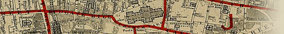
City Of London
1877
~ Click Here To View The Map Image Without Borders ~
The Map
| Full Title: |
School Board Of London - City Of London |

View The Label |
| Publisher: |
Stanford's Geogl. Estabt. London |
| Date: |
1877 |
| Size: |
28.7cm x 17.8cm (11¼" x 7") |
| Scale: |
6" : 1 Mile |
| Extent: |
City of London |
| Description: |
Title top left. Imprint and scale in bottom margin.
The School Board Of London map, City of London Division, is recorded in Hyde as No. 168 [ii]. |
Stanford's School Board Map was produced in 1877 at the request of the School Board Of London. The School Board was formed as a result of the Education Act of 1870 to ensure that every child in the country between the age of 5 and 13 attended school. The maps were produced to illustrate the locations of existing schools and show the deficiencies in current school places, as well as
to show where new schools could be located.
Stanford used his highly detailed Library Map Of London And Its Suburbs as the base map for production of the London School Board Maps. Stanford's Library Map was first published in 1862, with 10 further editions issued in the years leading up to 1877. It is recorded in Hyde as No. 91, with a total number of 21 editions or states between 1862 and 1901.
It is interesting to note that the School Board of London only requested 200 sets of Stanford's original 1877 School Board map. These were distributed to School Board members, superintendents of the various London school divisions, school inspectors, and their assistants.
Each set consisted of 10 maps, being:
- Chelsea
- City Of London
- Finsbury
- Greenwich (Consisting of 2 sheets, Greenwich East & Greenwich West)
- Hackney
- Lambeth (Consisting of 2 sheets, Lambeth East & Lambeth West)
- Marylebone
- Southwark
- Tower Hamlets
- Westminster
The map of the City Of London Division displayed here has been scanned at a large image size to ensure clarity of detail.
I hope that you find this map interesting and useful.
Image Sizes and Download Times
The average image size of the City of London Division map is approximately 450KB. At 56KB dial-up connection speed each page will take about 60 seconds to fully load, although some pages (such as London Wall & Eastcheap) can take approximately 90 seconds to load.
Please be patient, as it is worth the wait.
|