|
Topographical Survey Of The Borough Of St. Marylebone 1834
The Map
| Full Title: |
Topographical Survey Of The Borough Of St. Marylebone, As Incorporated & Defined By Act Of Parliament 1832. Embracing & Marking The Boundaries Of The Parishes Of St. Marylebone, St. Pancras, & Paddington, Also The Extents & Limits Of The Principal Landed Estates Within The Borough, And Plans & Elevations Of The Public Buildings.
Engraved by B.R. Davies From Surveys & Drawings By F.A. Bartlett Under The Direction Of John Britton F.S.A. &c. &c. &c.
Inscribed To The Dukes Of Bedford, Portland, & St. Albans, The Marquis Camden, The Lord Bishop Of London, Lords Mansfield & Southampton, E.B. Portman, Esq., & Other Landed Proprietors. |
|
| Mapmaker: |
Engraved by B.R. Davies From Surveys & Drawings By F.A. Bartlett Under The Direction Of John Britton F.S.A. &c. &c. &c. |
| Publisher: |
London. Published June 25, 1837; By J. Britton, Burton Str. J. Taylor, 30 Upper Gower Str. & B.R. Davies, 16 George Str. Euston Squ: |
| Date Of Map: |
1834 |
| Date Published: |
25 June 1837 |
| Size: |
114.5cm x 95cm (45" x 37½")
Each Section 28.5cm x 24cm (11¼" x 9½") |
| Scale: |
8.81" : 1 British Statute Mile
5" : 1000 Yards (Approx.) |
| Extent: |
St. Marylebone - St. Pancras - Paddington |
| Description: |
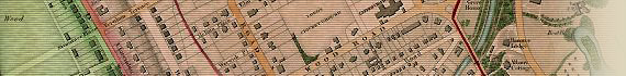
Folding map of St. Marylebone. 16 hand coloured sections laid down on linen, folding into a hardback cover, in good condition. The map is in excellent condition, with only minor offsetting and age toning.
The label on cover reads "Survey Of The Borough Of St. Mary-le-bone 1834." The information on the map is updated to 1834. The map records:
London & Birmingham Railway began 1834
Christ Chapel, Northwick Terrace 1834
Click the image below for an enlarged view of the label. |

Enlarged views of the Plans & Elevations of the Public Buildings can be viewed here:

View The Plans & Elevations Of The Public Buildings
A contemporary hand written inscription on the map endpaper reads "Parish Of St. Marylebone 1832. Published 1837."
You can view the inscription, the "Reference To The Principal Estates Within The Borough," and the "Borough & Parochial Statistics" by clicking the images below:
How To Use These Map Pages
Use the thumbnail map at the top of each page to navigate your way around the map.
Hovering your mouse pointer over the thumbnails will highlight the individual sections, and display a pop-up message showing the northern and southern extent of that map section, or significant streets, buildings and places. Click the desired area to jump to a page displaying a full size image of that map section. You will need to scroll down the page a little to see the image of the map.
A coloured thumbnail image on the thumbnail map at the top of the page will show you which section of the entire map you are currently viewing.
Click To Enlarge
Once you are viewing the desired map section, you can click on the map image to view an enlarged image of that section. Clicking on the map image allows you to switch back and forth ('toggle') between the normal sized image and the enlarged view of the section.
|