|
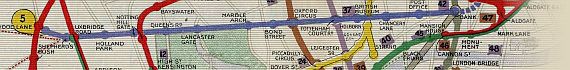
The Underground Map Of London 1911

~ Click For An Enlarged Image ~
The Map
| Full Title: |
The Underground Map Of London 1911
|
| Publisher: |
Johnson, Riddle, & Co. Ltd., London, S.E. |
| Date: |
1911 |
| Source: |
Taken From "Cook's Handbook For London. With Two Maps And Six Plans." |
| Publisher: |
Thomas Cook & Son, Ludgate Circus. Simpkin, Marshall, Hamilton, Kent & Co., Ltd. |
| Size: |
27.2cm x 20.5cm (10¾" x 8") |
| Extent: |
Golders Green - Whitechapel - Clapham Common - South Ealing |
| Description: |
Folding paper map of London Underground. Machine colour. Bound into "Cook's Handbook For London". In very good condition.
The map includes details of the Metropolitan Railway, District Railway, City & South London Railway, Central London Railway, Great Northern & City Railway, London Electric Railway (Bakerloo Line, Piccadilly Line, & Hampstead Line), Brighton Railway (Elevated Electric), & Waterloo & City Railway.
This map will be of interest to family historians researching their family in the 1911 Census of London.
I hope that you find this map useful. |
|