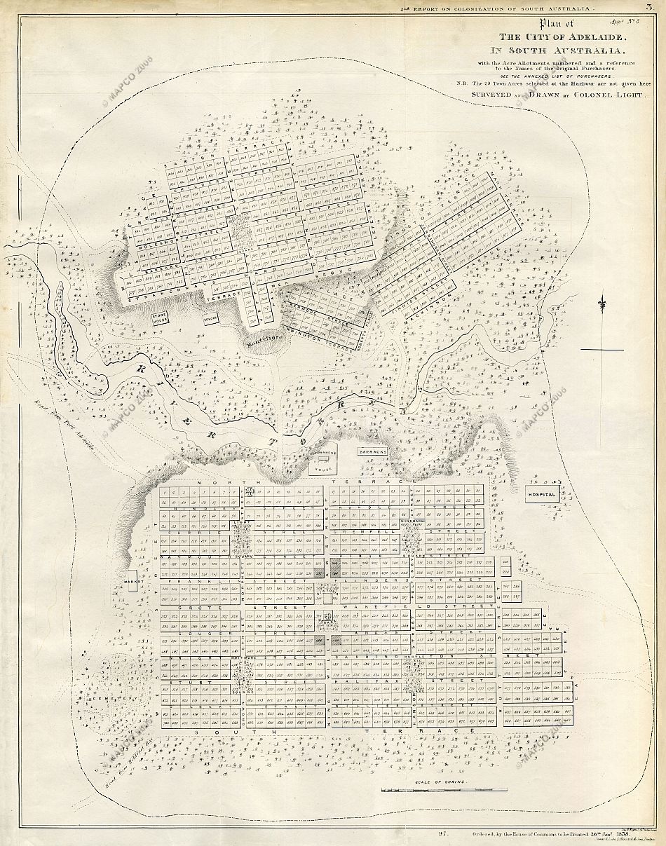
Plan Of The City Of Adelaide In South Australia
Surveyed And Drawn By Colonel Light 1837
Click The Image Below For An Enlarged View |
This Image © Copyright MAPCO 2006 |

~ Click For An Enlarged Image ~
The Map
| Full Title: |
Plan Of The City Of Adelaide In South Australia.
With The Acre Allotments Numbered And A Reference To The Names Of The Original Purchasers. |
|
| Mapmaker: |
|
| Publisher: |
James & Luke G. Hansard & Sons, Printers |
| Date: |
26th January, 1838 |
| Source: |
Second Annual Report Of The Colonization Commissioners For South Australia To Her Majesty's Principal Secretary Of State For The Colonies 1837.
22 December 1837.
Presented pursuant to Act 4 & 5 Will IV. c. 95.
Ordered, by the House of Commons, to be Printed, 26 January 1838. |
| Size: |
56.5cm x 44.5cm (22¼" x 17½") |
| Scale: |
1" : Approx 2½ Chains
8½" : Approx 1 British Statute Mile |
| Extent: |
North Park Lands - East Park Lands - South Park Lands - West Park Lands |
| Description: |
Folding paper map of Adelaide, South Australia. Folds into Report Of The Colonization Commissioners. Disbound, but in very good condition.
|
The Parliamentary report and map of Adelaide are particularly fascinating because they include a "Reference To The Plan Of Adelaide, In South Australia, With The Acre Allotments Numbered And A Reference To The Names Of The Original Purchasers". This reference records names familiar to all Adelaidians, including Robert Addison, Lieutenant
Finniss, Henry Gouger, Pasco St. Leger Grenfell, Osmond Gilles, John Gouger, Robert Gouger, Thomas Gilbert, John Hallett, Governor Hindmarsh, G.S. Kingston, Captain Lipson, Colonel Light, George Morphett, John Morphett, N. Morphett, Thomas Playford, E. Stephens, Samuel Stephens, G.B. Strangways, Captain Wright, and many others. The report is addressed to The Right Honourable Lord Glenelg, and is signed
by Robert Torrens, Samuel Mills, Jacob Montefiore, James Pennington, Josiah Roberts, John George Shaw LeFevre, Edward Barnard, and William Hutt.
The "Second Report Of The Colonization Commissioners", dated 22 December 1837, gives a fascinating glimpse of the very early days of the young Colony of South Australia. Two other maps of historical interest are included in this report, being "A Survey Of The Coast On The East Side Of St. Vincents Gulf Made By Colonel Light, Surveyor General",
and "Nepean Bay, Kangaroo Island. From A Sketch By Colonel Light, Surveyor General For South Australia". Both of these maps will be displayed here in the near future.
MAPCO is fortunate to hold a copy of the "First Annual Report Of The Colonization Commissioners For South Australia 1836. Ordered, by the House of Commons, to be Printed 28th July, 1836", which includes an early map of South Australia entitled "Part of Southern Australia from the 132° to 141° degree
of East Longitude". You can preview these two items using the links above. Both items will be displayed in full during 2006.
MAPCO also holds a copy of the "Third Annual Report Of The Colonization Commissioners For South Australia 1839. Ordered, by the House of Commons, to be Printed 13th May, 1839". The third annual report includes a huge map of the Adelaide plains. This map is displayed here, and is entitled "The District
Of Adelaide, South Australia, As Divided Into Country Sections. From The Trigonometrical Surveys Of Colonel Light, Late Survr. Genl." This map also includes the names of the original landowners up to 1838.
I hope that you enjoy these intriguing glimpses into Adelaide's past.
How To Use These Map Pages
Enlarged View:
Click on the map image at the top of this page to view an enlarged image of this map. The enlarged image will display on a new web page.
To navigate back to the main map page (this page), click on the enlarged map image or the map title displayed at the top of the page.
Supersized View:
Click on the small thumbnail map image above to view a very large, highly detailed image of this map. The image file size is quite large, being 3.8Mb, and measuring 4000 pixels wide x 5082 pixels high. This highly detailed image will display on a new web page.
To navigate back to the main map page (this page), click on the enlarged map image or the map title displayed at the top of the page.
|


