|
The District Of Adelaide, South Australia,
As Divided Into Country Sections.
1839
Click The Image Below For Enlarged Views |
This Image © Copyright MAPCO 2006 |
The Map
| Full Title: |
The District Of Adelaide, South Australia, As Divided Into Country Sections. From The Trigonometrical Surveys Of Colonel Light, Late Survr. Genl. |
|
| Publisher: |
John Arrowsmith, 35 Essex St., Strand, London |
| Date: |
Febry 18th, 1839 |
| Source: |
Third Annual Report Of The Colonization Commissioners For South Australia To Her Majesty's Principal Secretary Of State For The Colonies 1838.
Presented pursuant to Act 4 & 5 Will IV. c. 95.
Ordered, by the House of Commons, to be Printed, 13 May 1839. |
| Size: |
64cm x 55cm (25¼" x 21½") |
| Scale: |
1½" : Approx 1 British Statute Mile |
| Extent: |
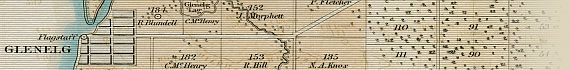
Gepps Cross - Athelstone - Flagstaff Hill - Semaphore |
| Description: |
Folding paper map of Adelaide, South Australia, and the Adelaide Plains. Hand coloured. Folds into Report Of The Colonization Commissioners. Disbound but in very good condition.
While this map was first printed in May of 1839, the survey work for it was actually carried out by Colonel William Light before June 1838, after which Light became the principal survey for the firm Light, Finniss & Co. When viewing this
map please bear in mind that the names recorded on it are accurate to 1838.
|
|
|
How To Use These Map Pages
Enlarged View:
Click on the thumbnail map images at the top of this page to view enlarged images of this map, and to navigate your way around the map. The enlarged images will display on a new web page.
Click on the map images displayed to view further enlargements of this map.
Click on the map title displayed at the top of each page to navigate back to the main map page (this page).
Supersized View:
Click on the magnifying glass icon or the words 'Click Here For Supersized Image' to view very large, highly detailed images of this map. The image file sizes are quite large, ranging from 3.24Mb to 3.8Mb, each measuring 4129 pixels wide x 4845 pixels high. These highly detailed images will display on a new web page.
Click on the map title displayed at the top of each page to navigate back to the main map page (this page).
Associated Maps Of Adelaide
You can also view other early maps of Adelaide and South Australia, taken from:
"First Annual Report Of The Colonization Commissioners Of South Australia" - 28 July 1836.
"Second Annual Report Of The Colonization Commissioners For South Australia" - 26 January 1838.
"Second Report From The Select Committee On South Australia." - 10 June 1841.
|