|
The District Of Adelaide, South Australia,
As Divided Into Country Sections.
1840
Click The Image Below For Enlarged Views |
This Image © Copyright MAPCO 2007 |
The Map
| Full Title: |
The District Of Adelaide, South Australia, As Divided Into Country Sections. From The Trigonometrical Surveys Of Colonel Light, Late Survr. Genl. John Arrowsmith, 10 Soho Square, 1839. |
|
| Date Of Map: |
London, Published Feby. 18th. 1840, by John Arrowsmith, 10 Soho Square. |
| Date Printed: |
June 10th. 1841. James & Luke J. Hansard Printers. |
| Publisher: |
John Arrowsmith, 10 Soho Square. |
| Source: |
Second Report From The Select Committee On South Australia: Together With The Minutes Of Evidence, Appendix, And Index.
Ordered By The House Of Commons To Be Printed 10 June 1841.
Appendix To Report From Second Select Committee On South Australia No. 2.
|
| Size: |
66.5cm x 54.5cm (26¼" x 21½") |
| Scale: |
1½" : Approx 1 British Statute Mile |
| Extent: |
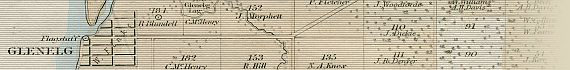
Gepps Cross - Athelstone - Flagstaff Hill - Semaphore |
| Description: |
Folding paper map of Adelaide, South Australia, and the Adelaide Plains. Hand coloured. Folds into Report From Second Select Committee On South Australia, 1841. Disbound but in very good condition.
|
MAPCO also has an earlier 1839 edition of this map on display. It is interesting to compare the 1840 map displayed here with the 1839 edition, as the 1840 map records the names of later purchasers of land across the Adelaide plains district.
Key to map in top right margin:

|
A _ _ _ S. Australian Co.
B _ _ _ Jno. A. Smith
P.R. _ _ Public Reserve
G.R. _ _ Govt. Reserve
|
|
Key to map below title:
 |
* Below this mark the rivers cease to run during the dry season.
O Stations of the Trigonometrical Survey.
The large sections contain 134 Acres each.
The small sections contain 80 Acres each.
|
|
How To Use These Map Pages
Enlarged View:
Click on the thumbnail map images at the top of this page to view enlarged images of this map, and to navigate your way around the map. The enlarged images will display on a new web page.
Click on the map images displayed to view further enlargements of this map.
Click on the map title displayed at the top of each page to navigate back to the main map page (this page).
Supersized View:
Click on the magnifying glass icon or the words 'Click Here For Supersized Image' to view very large, highly detailed images of this map. The image file sizes are quite large, ranging from 3.4Mb to 3.9Mb, each measuring 3906 pixels wide x 4870 pixels high. These highly detailed images will display on a new web page.
Click on the map title displayed at the top of each page to navigate back to the main map page (this page).
Associated Maps Of Adelaide
You can also view other early maps of Adelaide and South Australia, taken from:
"First Annual Report Of The Colonization Commissioners Of South Australia" - 28 July 1836.
"Second Annual Report Of The Colonization Commissioners For South Australia" - 26 January 1838.
"Third Annual Report Of The Colonization Commissioners For South Australia" - 13 May 1839.
|