Civitas
Londinum
A Survey
Of The
Cities
Of London
And Westminster,
The Borough
Of Southwark
And Parts
Adjacent
In The
Reign
Of Queen
Elizabeth
c1560
The Map
| Full Title: |
Civitas Londinum : A Survey Of The Cities Of London And Westminster,
The Borough Of Southwark And Parts Adjacent In The Reign Of Queen Elizabeth |
|
| Map-Maker: |
Attributed to Ralph Agas c1560 |
| Publisher: |
This facsimile published by Adams And Francis, London |
| Date: |
1874 |
| Size: |
75cm x 185cm (29½" x 72¾") |
| Scale: |
c.28" : 1 statute mile |
| Extent: |
Finsbury Field - Aldgate - Bankside - St. James's Park |
| Description: |
Engraved and Published from the Agas map held in the Guildhall
Library. Paper on linen, but not dissected, folded unevenly. Includes reference
letters and numbers on many buildings, but there is no key to these. Includes
notes by W.H. Overall, F.S.A., Librarian To The Corporation Of London. |
There are no surviving original c1560 copies
of the woodcut map entitled Civitas Londinum. Generally referred to as the Agas
map, the three surviving copies of this map were all published in 1633. The facsimile
of the map displayed on this site was published in 1874 by Edward J. Francis,
reproduced from the Agas map held in the Guildhall Library. It is catalogued in
Howgego as No. 8 (i). The map bears the
Royal arms of James I in the top left corner, and the City of London arms in the
top right. It has two panels with ornamental borders at the bottom. The left panel
contains an account of "This antient and famous City of London...",
the right panel a verse which begins "New Troy my name..."
There is a brief description of this map included on pages 10 & 11 of Pigot & Co.'s Metropolitan Guide c1820.
This is a fabulous and highly detailed map of London from the time of William Shakespeare and Queen Elizabeth I.
|
|
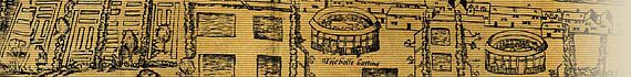
There are many places of interest illustrated on this map. Of considerable note
are the bull baiting and bear baiting arenas,
old St. Paul's Cathedral, and Old London Bridge.
The plan is in good condition for its age, although the binding
is poor and bumped. The map itself appears to have been clumsily assembled for
printing. The plates have been poorly aligned at the joins resulting in mismatching
and some missing detail, which I am assume was a fault with the 1633 woodblock
map rather than the 1874 facsimile. This is most apparent in the sections for
St Gyles In The Fyeld, Clarken Well,
Paris Garden, and in various other places also.
Brief History Of This Map
A bookplate affixed inside the front cover records that this copy was once the
property of the rather grandiose sounding Rev. Prebendary Hedgeland. Rev. Hedgeland,
M.A., of St. Mary's Church, Penzance, was a member of the Penzance
Natural History and Antiquarian Society from 1880–91, and President
of the Penzance Public Library in 1893.
This map came to MAPCO from a U.K. dealer in 2003.
Image Sizes and Download Times
The images displayed here are scans of half of each folded section. Presentation
of Civitas Londinum in this form means that there is no need to provide a second
enlarged view of the individual sections.
The average image size of the Agas map sections is approximately 560KB. At 56KB
dial-up connection speed each page will take about 60 seconds to fully load, although
some pages can take approximately 90 seconds to load.
Please be patient, as it is worth the wait.
|