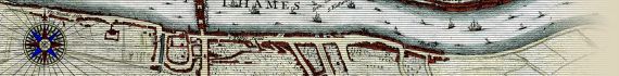
The City Of London As In Q. Elizabeth's Time
The Map
| Full Title: |
The City Of London As In Q. Elizabeth's Time;
or, in full,
The City Of London As In Queen Elizabeth's Time. |
|
| Map Maker: |
John Strype |
| Date: |
1720 |
| Size: |
45cm x 17.5cm (19½" x 9") |
| Source: |
Engraved for Stow's Survey of London (1720). See (2) below for details. |
| Extent: |
Moorfields - Limehouse - St Georges, Southwark - St James's Park. |
| Description: |
Original engraved print on paper with later hand colouring. In excellent condition.
Based on a map of London attributed to Ralph Agas. Refer to Howgego No. 2 (a) for details of Hatton's version of this map ( see (1) below).
This map was originally acquired by a U.S. collector from the map collection of a Wisconsin physician, offered for sale through a nationally advertised estate auction. The collection also included maps by Speed, Bowen, Ogilby, and others. MAPCO purchase this map from the next owner in 2009. |
There have been many different versions of this map printed over the centuries, amongst which are:
1) The City Of London As In Q. Elizabeth's Time.
Published 1708, London.
Taken from A New View Of London; or, an ample account of that city, in two volumes or eight sections. Being a more particular description thereof than has hitherto been known to be published of any city in the world, by Edward Hatton.
2) The City of London as in Q. Elizabeth�s Time.
Published 1720, London.
Taken from A Survey Of The Cities Of London And Westminster : Containing The Original, Antiquity, Increase, Modern Estate And Government Of Those Cities. Written At First In The Year MDXCVIII. By John Stow, Citizen And Native Of London, updated by John Strype to 1720.
This is the copy displayed on these webpages. A transcription of the title page from Strype's update of Stow's Survey is shown below.
3) The City of London as in Q. Elizabeth�s Time.
Published 1755, London.
Taken from A Survey Of The Cities Of London And Westminster : Containing The Original, Antiquity, Increase, Modern Estate And Government Of Those Cities. Written At First In The Year MDXCVIII. By John Stow, Citizen And Native Of London, printed for W. Innys, J. Richardson &c., 1754-1755.
Note that the version printed for Stow's Survey 1755 has the impression printed below the map "Printed According to Act of Parliament 1755 for Stow's Survey"
Street Index
All of the streets and places labelled on this map have been transcribed for reference below, and displayed on the pages for the individual map sections. However, a search facility would be of little benefit on these pages as the spelling of many streets and place names is in the Elizabethan fashion. To help with identification the transcription is shown below.
The lists below act as active links to the specific map sections, or the map can be viewed by using the thumbnail images above.
|
Street Index |
|
A
SURVEY
Of the CITIES of
London and Westminster :
CONTAINING
The Original, Antiquity, Increase, Modern Estate
and Government of those CITIES.
Written at first in the Year MDXCVIII.
By JOHN STOW, Citizen and Native of London.
Since Reprinted and Augmented by the Authors;
And afterwards by A.M.H.D and others.
NOW LASTLY,
Corrected, Improved, and very much Enlarged: And the SURVEY and HISTORY
brought down from the Year 1633, (being near Fourscore Years since it was last
printed) to the present Time;
By JOHN STRYPE, M.A. a Native also of the said CITY.
Illustrated with Exact Maps pf the City and Suburbs, and of all the Words; and
likewise of the Out-Parishes of LONDON and WESTMINSTER : Together with
many other fair Draughts of the more Eminent and Public Edifices and Monuments.
_______________________________________________________
In SIX BOOKS
_______________________________________________________
To which is prefixed,
The LIFE of the AUTHOR, writ by the Editor.
At the End is added,
An APPENDIX of certain Tracts, Discourses and Remarks,
concerning the State of the CITY of LONDON.
TOGETHER WITH
A Perambulation, or Circuit-Walk Four or Five Miles round about LONDON, to
the Parish Churches : Describing the Monuments of the Dead there Interred :
With other Antiquities observable in those Places.
And concluding with a SECOND APPENDIX, as a Supply and Review : And a Large
INDEX of the Whole Work.
_______________________________________________________
PEACE be within thy Walls, and
PLENTEOUSNESS within thy Palaces. Psal. cxxii. 7.
_______________________________________________________
LONDON
Printed for A. CHURCHILL, J. KNAPTON, R. KNAPLOCK, J. WALTHOE, E. HORNE,
B.TOOKE, D. MIDWINTER, B. COWSE, R. ROBINSON, AND T. WARD. MDCCXX
|
|
|
Section 2
St Gyles, Bloomsbury, Kings Gate, Long Acre, Drury Lane, Queen Street, Clare Street, Lincoln Inn Fields, St Martins Lane, Bedford Street, Piatzo, Charing Cross, Strand, Butchers Row, Temple Bar, White Hall, Savoy, Somerset House, Milford Lane, Temple Stairs, White Friars, Westminster Stairs, Parliament Stairs, The River Of Thames, Lambeth House |
Section 3
St Jones, Turnbolt Street, Hickes House, Long Lane, Barbican, Red Cross Lane, Golding Lane, White Cross Street, Beech Lane, Chiswell Street, Grub Street, Grays Inn Lane, Cow Lane, West Smithfield, Duck Lane, Little Brittain, Aldersgate Street, Holborn Barrs, Holborn, Bridge, Snow Hill, Pye Corner, Newgate, St Martin's, Shambles, Noble Street, Cripplegate, Little Wood Street,
Moorgate, Aldermanbury, Maiden Lane, Lad Lane, Cateaton Street, Foster Lane, Gutter Lane, Great Wood Street, Milk Street, St Laurences Lane, Ironmonger Lane, Chancery Lane, Fetter Lane, Shoe Lane, Old Baily, Temple Bar, Fleet Street, Ludgate, Creed Lane, Ave Mary Warwick, Paternoster Row, Pauls Church Yard, Cheap Side, Old Change, Friday Street, Bread Street, Bow Lane, Soper Lane, Watling Street, Water
Lane, Carter Lane, Ward Row, Addle Hill, Pauls Chain, Fish Street, Trinity Lane, Garlic Hill, Budge Row, Thames Street, Temple Stairs, White Fryars, Black Fryars, Pauls Wharf, Queenhithe, Three Cranes, The River Of Thames, The Bank Side |
Section 4
Chiswell Street, Moor Fields, Mear Lane, Moorgate, London Wall, Bishopgate Street, Artillery Lane, Artillery Ground, Spittle Fields, Hounds Ditch, Petticoat Lane, Colman Street, Cateaton Street, Throgmorton Street, Broad Street, St Bartholomew Lane, Ironmonger Lane, Old Jury, Poultry, Threadneedle Street, Cornhill, St Mary Acts, Dukes Place, Bevis Markes, Leadenhall Street, Aldgate,
Lombard Street, Wallbrook, Swithins Lane, Clements Lane, Gracechurch Street, Lime Street, Billiter Lane, Angel Alley, Fanchurch Street, Crouched Fryers, Minories, Rosemary Lane, Philpot Lane, Rood Lane, Mincing Lane, Mark Lane, Seething Lane, Hart Street, Budge Row, Cannon Street, East Cheap, Tower Street, Tower Hill, Dowgate, St Michel Lane, New Fish Street, Pudding Lane, Botolph Lane, Love Lane, St
Mary Hill, St Dunstan Lane, Harp Lane, Water Lane, Beer Lane, Tower Dock, The Tower, Thames Street, Stillyard, Old Swan, London Bridge, Billingsgate, Cliftom House, Tower Wharf, The River Of Thames, The Bank Side, St Tooly's Street, St Georges, Barnaby Street |
Section 5
White Chapple, Rosemary Lane, Ratcliffe, Nightingale Lane, St Katherines, Warring, Iron Gate, St Katerines, The River Of Thames, Redriff, Barnaby Street |
|
How To Use These Map Pages
Use the thumbnail map at the top of each page to navigate your way around the map.
Hovering your mouse pointer over the thumbnails will highlight the individual sections, and display a pop-up message showing the features and landmarks shown on that map section. Click the desired area to jump to a page displaying a full size image of that map section. You will need to scroll down the page a little to see the image of the map.
A coloured thumbnail image on the thumbnail map at the top of the page will show you which section of the entire map you are currently viewing.
Click To Enlarge
Once you are viewing the desired map section, you can click on the map image to view an enlarged image of that section.
Clicking on the map images allows you to switch back and forth ('toggle') between the normal sized image and the enlarged view of the section.
|